My thinking hasn't changed regarding the coming cold spell. Models again are NOT bringing down the Polar Vortex over the Great Lakes and I think that will keep the hard freeze threat to the North Shore and not south of Lake Pontchartrain. The coldest mornings will be Tuesday, Wednesday & Thursday before milder air returns for next Friday. Let's begin with why we will have a freeze threat. Temps in Canada & Alaska are 45-50 below zero.
Those brutal temps will plunge down over the Great Lakes and Northeast making it feel like the way January used to feel, cold & snowy. But I don't see the dip in the upper flow sharpening down to the Gulf coast. Pay attention to the big low off the West coast. The top view is the flow from this morning.
That system moves into Oklahoma on Sunday bringing us a level 2 risk for severe storms ahead of the Arctic cold front.. But look where that low goes. It opens up as a trough over the Northeast.
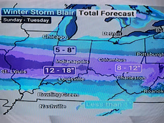
I grabbed these graphics off The Weather Channel where they take a Snow & Ice storm out of the Rockies to the East Coast. But look at another system coming from the West Coast for next Thursday.
IF that proves accurate, it might trigger a Gulf Low for late next week. We will still be in the Arctic air, but will it be cold enough for it to be frozen precip. here? Many days to watch it. Let's focus on the short term where we have low clouds just off our coast.
A weak front is approaching, but it should come to a halt near us for Saturday.
The really frigid air remains well to the north, but notice the below zero temps starting to show up in the Dakotas. Some of that chill will arrive here before daybreak on Monday. But before then, we jump into the warm air sector on Sunday bringing us that PM severe weather threat. The top is Sunday AM followed by Sunday PM.
Most of Sunday will be warm & dry with highs 75-80. The big chill comes after midnight. I will begin to prepare my yard tomorrow by picking all my grapefruit. I'll move my tropical plants into my He-Shed but will hold off on covering my inground plants until I see future model runs. We'll have all day Sunday to do that IF a freeze is coming. Next update tomorrow PM. Stay tuned!


No comments:
Post a Comment