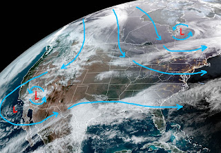
With all the snow gone and no Freeze threat during the next 10-14 days, our focus shifts to the next rain threat. A weak cold front moved through today, but the rain along the front fizzled as it reached us. From Baton Rouge to McComb a good soaking rain fell (.50-1.00+). During the Winter months, low clouds often linger behind a frontal boundary and that will be the case this week.
It's hard to find the front as temperatures behind it are not much cooler. There is drier air to our north, but that good feel air will not make it to us as a storm over California heads our way. I've drawn in the return flow of low level moisture (lime green arrows)
Cold air is still coming out of Canada, but the real Arctic Chill has retreated back into eastern Canada. There are no signs of that air coming back down to us during the next 2 weeks.
I'm happy with our 60s during the day and 40s at night. A concern later this week will be dense sea fog as local waters are much colder from last week's freeze.
It's quite a turnaround from last week's snowstorm. We will have to pay attention on Friday when another Pacific front could bring us some strong storms. Plenty of time to watch it. Now it's back to golf!!! Stay tuned!


No comments:
Post a Comment