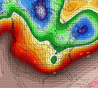
If you have been reading social media for the past few days, you would wonder if the end is coming. Yikes, so many "weather blogs" talking doom & gloom coming to the eastern states. Hey, yes it will get much colder. Yes, there will be several snowstorms. Yes, it is January and it's supposed to be cold and snowy! Here's what I mean about overhype starting with the Polar Vortex. Where is it now? Can't see it as the main vortex is up over the North Pole with a small rotation east of Hudson Bay.
That's confirmed by this morning's map. But does the main Polar Vortex dip to the south? Not if the models are correct. We begin with the forecast valid for next Monday. One vortex remains east of Hudson Bay with the main Polar Vortex dropping into Canada.
But that Polar Vortex does not drop southward if the bottom graphic proves true for NEXT Thursday. However, note the weaker low over west Texas. That could be the disturbance that triggers the southern snowstorm. So here's my thoughts based on NO Polar Vortex descending into the lower 48. The core of the frigid cold will stay to our north and east this time. My concern regards future model runs that might sharpen the East Coast trough. Look at the chill up in Canada & Alaska.
No longer is Canada mild. In fact, the core of the cold over Alaska has it 45-50 degrees below zero. But without that Polar Vortex dropping to the south, the really frigid air targets the Great Lakes and Northeast. I am not going to start bringing in my plants nor preparing my yard just yet. We can wait to see future model runs before making that call. In the short term, clouds are coming back for Friday.
As you can see, the freeze line remains far to our north with the sub-zero reading just showing up over North Dakota. We'll stay mild into Sunday PM.


No comments:
Post a Comment