
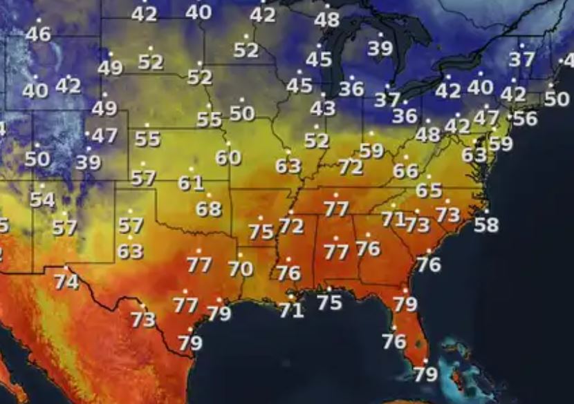
Gosh, what a beautiful day to be outside as temps are in the mid to upper 70s. This gets us gardeners thinking about re-planting all the stuff we lost in the January & February freezes. But not so fast Gang, as we can have minor freezes well into March and frost into early April. What makes me nervous is seeing the super cold (25-30 below) air up across Alaska & northern Canada.


That chill can't come down to us without a deep East Coast upper trough, which will happen during the second week in March. As you can see, we actually have an upper ridge across Texas that has allowed some real spring-like warmth over the south. That weak upper trough (yellow dashes) will drag a weak cool front through us, but it will not bring us much cooling.


There are no showers with the western end of this front with the main rains streaking across Indiana & Ohio. You may not even notice it with only some lower dew points/drier air behind it for Friday.


This quiet stretch of weather comes at the perfect time as we have nightly parades rolling. Newest model runs are indicating our next real cold front doesn't arrive until Ash Wednesday. That means near-perfect weather for all of the super krewes & on Mardi Gras itself.


Who da thunk we'd be in the 70s after last week's chill? Geez, it's really hard to find new stuff to talk about. However, how's this. We all heard the Army Corps of Engineers has a lever one alert for high water on the Mississippi River after the Carrollton gauge topped 11 feet. You can really see the muddy waters on today's satellite view.

The muddy waters in Lake Pontchartrain are coming from water seepage through the Bonne Carre Spillway blocks. Based on right now, the Corps has no plans to open the Spillway UNLESS we see unusually heavy rains farther upstream over the Upper Mississippi & Ohio Valley. The current high waters are due to combined snow melt & recent rains. With the snow gone, river levels should slowly fall later in March...UNLESS. Stay tuned!
No comments:
Post a Comment