Every station now has a branding, but whatever you call it (Alert, Impact, Warning), tonight is PAT time (Pay Attention Time). If you have the FOX 8 Weather App, you know SPC placed us under a tornado Watch earlier this afternoon until 8 PM They issued a second watch farther to the NE for Mississippi until 10 PM.
The greater severe risk (according to SPC) is north and east of Lake Pontchartrain, where a level 3 risk (Enhanced) means several strong tornadoes are expected.Clearly radar has the bulk of the storms going to our north and several warnings are in effect.
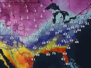
The radar echoes have formed several SSW to NNE lines with heavy rains and lots of lightning. The danger times for the North Shore will be after 4 PM through 9 PM with the South Shore danger coming between 6-10 PM. What's causing this severe threat? We are in the warm air sector with a strong cold front plowing into it. Note, Houston is in the 50s!
Couple in dew points (low level moisture) in the 70s with a SW upper jet stream and that is why we have the POTENTIAL for severe storms this evening. Also, an Arctic airmass has descended over the Rockies and Central Plains. We need to PAT (Pay Attention Time) again later this week in case the East Coast trough dips farther to the south than currently predicted.
It's 81 at Brownsville and 15 at Amarillo !
You can see the dip on the mid level (15-18,000') Water Vapor loop. Models are NOT bringing that dip into the SE and that should keep any freezing temps to our north and east. Note all the little disturbances rotating around the upper trough. Bottom line, keep up on the weather this evening and have that FOX 8 Weather App ready to alert you IF warnings are issued. AT 3 PM, several strong storms are over St. Tammany.
Winds are gusting to 30+ mph so even if you don't get a strong storm, winds could gusts to 40 mph this evening. Changes arrive for Thursday as it's back to sweaters and jackets. I'm posting early due to the severe potential, so for the latest 7 day forecast, check with FOX 8 at 4 & 5 PM.
Again, the cool down for Sunday through Tuesday could be worse IF the upper trough shifts to the East Coast. The immediate concern is tonight's storms. It's PAT (Pay Attention Time) for the next 6-8 hours. IF you're dressed for it, tomorrow will feel much better. Stay tuned!


.jpg)


No comments:
Post a Comment