Our weather has been like yesterday's Super Bowl, (unless Philly fans!) boring with little day-to-day changes. But that's about to end as the upper pattern undergoes major shifts during the next 10-14 days. The main upper trough remains along the West coast keeping the coldest air north of the Gulf coast. However, most of Canada remains below zero with some super cold (25-30+ below) over NE Canada.
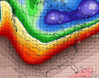
The top graphic is the Water Vapor in the mid to upper lever (15-20,000') with the steering flow showing the dip over the west and a WSW flow across most of the nation. The Arctic chill covers Canada and any shift in the upper trough brings the cold back into the lower 48. Here's what the GFS model is saying beginning with today's flow on top.
The trough along the West Coast today shifts over the Great Lakes by Thursday (middle graphic), but lifts out by this Saturday as a new trough develops farther to the west over the central Plains. (bottom pic) IF that turns out to be reality, our upper flow will stay WSW. Each trough will bring waves of rain/snow with the second system on Saturday being the stronger. Here's the rain totals for the next 7 days along with the severe risk area for Saturday.
Clearly, the heavier rains and higher storm risks are to our north, but not by much. Our boring weather is about to become active. A weak frontal boundary pushed down to us today, but has stalled out.
It certainly is colder north of the front with Dallas & Shreveport in the 40s! Note Houston is still in the 70s and south of the boundary dew points remain 60+. So what will finally bring the cold air back down to us? The upper pattern shift. Here's the GFS model valid for Monday 2-17 with the Polar Vortex just north of the Great Lakes.
However, by Wednesday 2-19th, the Vortex pulls back to the NE as a new trough drops out of the Rockies. That pattern shift continues into the week before Mardi Gras. By next Saturday (2-22) the trough stays across the Plains, but see what it does the following week.
The bottom view is valid for Saturday 2-26. The trough has sharpened with the flow coming straight out of Canada. IF this model is correct, all you cold air geeks will be in your glory for the last half of this month. It'll be back to heavy coats for those Mardi Gras parades.
The immediate outlook does show the cooling, but we have no freeze threat into next week. Here's what makes me nervous.
It's below zero across Montana & North Dakota, but isn't that where the flow comes from after the upper trough shifts back over the Great Lakes by late next week? Super Bowl week was warm and mostly dry. Mardi Gras weekend into Fat Tuesday, much colder! Wet or Dry? Too soon to tell. Stay tuned!


.jpg)

No comments:
Post a Comment