
9 years ago (March 3, 2016) I began my first day of "retirement" flying down to Puerto Vallarta to party with our friends Mark & Ivan. Back then, it would be unheard of to cancel any parades 1-2 days ahead of time. Well, we have all witnessed the tremendous increase in technology that now allows computer graphics to give us hour by hour maps for rainfall, winds, & even snow (remember January?!!) days in advance. Are they always correct? No, but more often than not they are. That is why Jefferson (a way more exposed parade route ) cancelled all parades and Orleans has limited the scope of Zulu & Rex. So what is causing all these precautions? Let's begin with the set up. There is a powerful upper disturbance centered over Utah this afternoon as depicted on Water Vapor.


A surface dry line (Brown dashes) has developed over OK/TX with a rich low level flow of Gulf moisture surging northward. SPC (Storm Prediction Center) has highlighted an area where they expect storms to fire this evening.


The bottom graphic shifts that area eastward and expands it along the MS/AL coasts for Tuesday. Clearly, the greatest threat/risk is centered to our north, but not by much. All of the North Shore is under a level 3 (Enhanced) risk.


The local NWS office has some easy to understand graphics on their web page. Based on what I'm seeing, the curtailment of parades is wise & a matter of public safety. Gusts to 50+ would make float riding & throwing difficult, if not dangerous.


With such strong SSE winds, NWS has issued a coastal flood advisory for high water outside the flood protection/reduction levees. Yeah, it stinks, but Tuesday is a pay attention day.


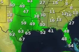
IF we see any sunshine, temps could jump into the lower 80s. Note the surge in dew points across Texas from Houston/Austin southward. That is the fuel that could be ignited by the approaching upper disturbance.


While the South Shore saw a lot of sunshine, the North Shore stayed mostly cloudy.

So we will see some strong storms tomorrow afternoon & evening. Mardi Gras will be limited, but it will NOT be cancelled. We will be cooler & drier for Wednesday & Thursday with another front approaching late Saturday. Stay safe & stay tuned! Happy Mardi Gras Gang!!!
No comments:
Post a Comment