We have not yet reached the time when daytime heating becomes the driver of our daily T-Storms. That'll happen by late April into May. For now, we typically need a surface boundary (cold front) or an upper disturbance to provide the lift for showers & storms. Models are indicating several upper features that are already causing heavy rains over South Texas, which will increase our rain chances here Friday & Saturday. Let's begin with the upper air pattern.
You can see these features in the southern stream. They are bringing much needed rains to south Texas.
That's exactly where the Drought Monitor has the worse drought. WPC rainfall graphic has the heaviest rains over south Texas. The top view is for the next 2 days (Thursday-Friday).
The bottom is the 3 day total through Saturday. Note there is a shift into SW LA. closer to us. But it doesn't keep coming. SPC kind of agrees that these upper systems will WEAKEN as they approach us. The top graphic is the severe risk for Thursday, followed by Friday.
SPC doesn't have more than a level one risk to our west on Friday, so I'm optimistic that whatever rains come over us this weekend will not have any severe storms.
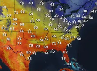
There is quite a moisture boundary setting up from Texas to Florida. Dew points in the 30s north of the boundary with 60 & 70 dew points to the south. Any upper disturbance that tracks over us has plenty of fuel to develop showers with some thunder. The remaining issue is timing. What I'm seeing is several waves coming by with the first Friday PM and other rounds on Saturday & Sunday. Check with the latest model runs on FOX 8 as we get closer to the weekend.
Before you think we're done with cold fronts, I'm seeing a decent shot of cool air coming during weeks 1-2 in April. Don't put the sweaters away just yet. Stay tuned!


No comments:
Post a Comment