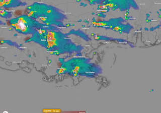
For several days, models were indicating increasing rain chances. I downplayed any increase since breaking out of a multi-week dry spell is often difficult. I was wrong, but the models were hardly right either as 4-8" of rain fell in two bullseyes. Bruce commented last night that predicting exact locations for the heavy rain events is a huge forecast challenge. My question is...why did the storms bubble up right over the South Shore and not drift across the Lake to the North Shore? Little movement.
Channel 8's ground truth weather watchers came in under the radar estimates, but the Orleans S&WB locations did have several close to radar estimates. So here's the problem at this time of the year. Fronts run out of "gas/momentum" as the jet stream retreats farther to the north. Fronts stall/dissipate leaving behind boundaries that, coupled with upper disturbances, trigger slow-moving flooding rain storms.
It's impossible to predict the exact location where the heavy storms will bubble up. Until the upper pattern changes this weekend, we'll have a higher rain threat for the next 1-2 days.
By Friday into Sunday, an upper ridge will develop reducing our daily rain chances to near zero. We all know during the summer months, no rain means no relief from the heat. You can see that on current 4 PM temps. Where it's raining it's cooler.
Actually, the decreasing rain chances will come just in time for Jazz Fest & the Zurich Golf Classic. But for today & tomorrow, keep the rain gear handy.
Looking at the temperatures, it's time to put away the winter gear and get your sweaters to the cleaners. I do see another cold front coming late NEXT week, but they are no longer cold. Stay tuned!


No comments:
Post a Comment