
NHC has slightly increased the chances for the development of INVEST 93L to 40%. What I don't understand is why their Tropical Weather Outlook has not shifted their highlighted area farther to the north based on satellite view.


Clearly, the surface circulation is over land in northern Florida, and its center is exposed. The color IR view has all the storms being blown off to the SW due to strong upper NE winds. The water vapor view continues to have a hostile environment over the Gulf with a large upper low over the western Gulf.


Without a well-defined surface center, the spaghetti plots are all over the place.


The bottom view (fewer models) keeps any center hugging the northern Gulf Coast, and that should limit development. As Zack said days ago, our greatest threat from whatever forms will be periods of heavy rainfall that will produce street flooding.


The current thinking is that the heaviest rains will stay south of NOLA along our coast. NWS gives two different scenarios, most likely and worst case.
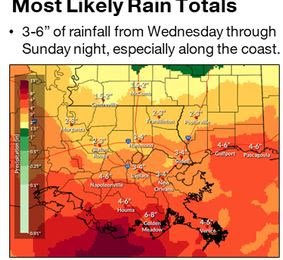

My thinking, based on current movement, is for 1-3" north of Lake Pontchartrain, 3-5" on the South Shore with 6-8"+ along the coast. Bottom line, Thursday and Friday will be very wet at times. I mentioned yesterday that 93L/Dexter? should not be a life-threatening event, unless one is stupid and is outside during the heavy rains and/or drives into deep water. Let's keep everyone safe on Thursday and Friday.


Otherwise, it's basic summertime across all of the Southeast.

Once this system passes by Friday, our weekend will get back to normal daily showers. I'm happy this disturbance is coming this weekend because the following weekend is the Grand Isle Tarpon Rodeo.

Fishing begins at dawn on Thursday, July 24th & concludes under the Otto Candies Pavilion Saturday night, July 26th, with the awards presentation. The final Grand Prize award ($10,000) will be pulled by this year's Rodeo Queen. All folks who register have an opportunity to win. You don't have to fish or even be on the Island. Just register ($55) at tarponrodeo.org and you could have your next vacation paid for! Such a deal and what great odds! Will I call your name next Saturday night? Finally,

Have any of you noticed the other swirl over the Gulf? It's west of Key West and has no storms with it yet. Just the weather geek in me. Stay tuned!
No comments:
Post a Comment