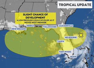
Surprisingly, NHC has not increased chances for development in the system east of Florida. There certainly is low-mid level circulation on satellite and radar, but strong upper NE wind shear will limit any explosive growth. By designating this system INVEST 93 L, that allows computer models to do initial runs. Let's review what we know.
The light blue arrows show the upper wind shear while the color view has the strongest (highest cloud tops) T-Storms over Florida and not with 93L. Early spaghetti plots are kinda useless.
Satellite motion definitely is from NE to SW, yet models seem to want to take 93L inland and not into the Gulf. Whatever, the environment across the Gulf is quite hostile right now with strong upper winds.
All the focus will be on 93L/TD 4/Dexter for the rest of this week. The main impacts for us would be rising tides & inland flooding. It's far too soon to say it won't be a big deal (my thinking) and we all need to monitor this disturbance beginning Wednesday through Saturday.
Note how the rain chances ramp up for Thursday & Friday. IF early model runs prove reality, most of the moisture/rainfall would stay to our east. No immediate concerns, but that could change. Remember, computer models do not handle weak systems very well, so we watch & wait. Stay tuned!


No comments:
Post a Comment