Wednesday, August 28, 2019
Dorian Getting Stronger...
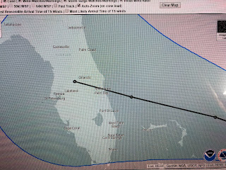
I'm writing this waiting for the next update at 10 pm. What I'm seeing on satellite loops is a slowly strengthening system pulling away from Puerto Rico heading northward to the open, warm waters of the Atlantic. Recon is finding pressure drops continuing and the next advisory probably will increase the winds to 85-90 mph. David Bernard gave a very understandable explanation of the uncertainties involved in the future path of Dorian at 9 PM. I would suspect NHC will not have any major changes to their track forecast as they don't want to start flip-flopping with each model run. As I previously mentioned, the northern Gulf is not totally "out of the woods" with this storm, although the chances for us being impacted remain very slim. OK, the 10 pm update is in and winds are up to 85 mph and the track is essentially the same as before, which is good for us as NHC did not continue the southward shift in the track. Let's hope the expected blocking high to the north is not as strong and Dorian can take a more northern path keeping it out of the Gulf. Watch that centerline shift update to update as it will give you the thinking of the forecasters at NHC. We want that northern shift and not the southern one. Way too soon to know which one wins out. Stay tuned!
Subscribe to:
Post Comments (Atom)


No comments:
Post a Comment