Thursday, September 5, 2019
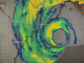
Eyewall Near Charleston...
Satellite loops are showing that Dorian's circulation is beginning to entrain some drier air on the western side, plus part of the circulation is now over land. However, NHC is keeping him a Cat. 3 storm and the eyewall sits just offshore from Charleston. The massive 10' storm surge up Charleston's harbor didn't happen and when the next high tide comes this afternoon, Dorian's winds will have turned to the north pushing water out. It appears North Carolina will see greater impacts as Dorian touches their coast later today.
Nothing is happening in the Gulf into next week. We just have to deal with some later season record breaking heat. Be cautious and stay hydrated. Stay tuned!
Subscribe to:
Post Comments (Atom)


No comments:
Post a Comment