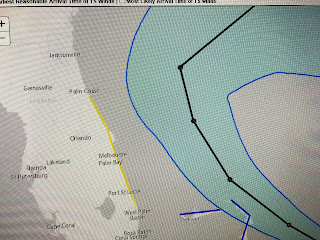
Satellite loops still show disorganized T-Storms to the north and east of the center as wind shear continues to hinder development. However, in their latest discussion, NHC believes TD 9 will become Hurricane Humberto over the weekend into next week. Bruce at 4 PM clearly pointed out multiple centers on the visible (daylight) loop and that usually means any development will be slow. The biggest news is they have relocated the center farther to the east and that diminishes any threat to the U.S. East Coast. In fact, the cone of error is now well offshore from Florida & the Carolinas and it would take some strange turn of events (stalling, making a loop) for this system to impact any land areas.
These are the kinds of storms we like, staying out of the Gulf and even missing the U.S. entirely. There are several more disturbances out in the Atlantic and I can almost promise you future threats are ahead since we haven't even reached mid-September. Closer to home, a well defined upper low is drifting across the central Gulf and some storms have fired off on the eastern side. Models don't show development & NHC doesn't mention it in their discussions. It's just something to watch as slow moving upper features occasionally work their way down to the surface.
The bottom line for our local forecast is little change with more record heat likely into next week. Long range models don't have a real cold front coming before the last week in September. I know, this heat is getting old. Think OCTOBER ! Stay tuned!


No comments:
Post a Comment