We still are seeing clusters of disorganized T-Storms over the southern Gulf and NHC is giving an area off the Yucatan a slight (20%) chance for development. None of the models bring this system northward, but instead take it to the west.
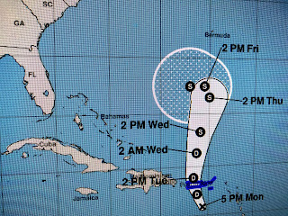
Jerry is still lingering out over the Atlantic and will finally drift out to sea. Karen has been downgraded to a Depression as strong upper wind shear has weakened her. Some models still show a turn back towards the east coast late this weekend, if she can survive the current shear.
Models continue to indicate our first REAL cold front arriving late NEXT week (Oct. 4-5th), and based on the slow movement of Karen, that front would block and movement into the Gulf towards us. Finally, Tropical Storm Lorenzo is getting stronger, but he's way out in the Atlantic and will turn to the north affecting only shipping.
I'll have some comments tonight or tomorrow on Today's Climate (Global Warming) Summit at the U.N. Interesting to note the line under the Headline. That should tell you something.


No comments:
Post a Comment