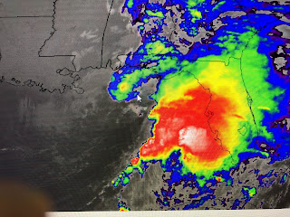
NHC hasn't changed their earlier track taking the centerline right over Mexico Beach.
The forward speed has increased to 23 mph and Nestor will be inland shortly after daybreak. The worst part of the storm, with greatest impacts will be east of the centerline. Central Florida is getting a soaking with a real tornado threat tonight.
The arrow points out the center with the heaviest storms well to the east & southeast. The Panhandle is getting some needed rainfall, but the severe threat will be over central Florida. As Nestor is now to our east, cooler and drier air is rotating around him making us feel almost chilly tonight. Once the sun returns on Saturday, highs will quickly warm back to 75-80 making it near perfect. By Sunday PM, Gulf moisture will start returning with a T-Storm threat coming on Monday ahead of our next cold front. Hard to believe, but we are really over summer and will start to feel like Fall for the rest of this month. Enjoy your weekend and go Saints in Chicago.. Who Dat! Stay tuned!


No comments:
Post a Comment