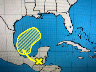
Yesterday I mentioned that it is not unusual to have a late season tropical storm develop along an old frontal boundary across the southern Gulf. Today NHC started to highlight the area giving it a 30% chance to develop. Fortunately for us, another cold front will arrive that will block anything that forms keeping it well to our south and east. The Euro now gives that area a moderate chance for development.
The next named storm would be Olga, but she should be blocked from coming towards us. That doesn't mean we will not see moisture from that system. In fact, models are showing a surge of tropical moisture moving over us giving us the potential for 2=3"+ for Friday into early Saturday. Cooler and drier air returns for Saturday PM into Monday with another stronger front coming for next Wednesday. The cold air is building with 30s & 40s across the northern states and even some below zero readings showing up in interior Alaska.
It's only a matter of time before we start singing "Baby it's cold outside". I won't start whining until we get into the 40s on the South Shore. Stay tuned!


No comments:
Post a Comment