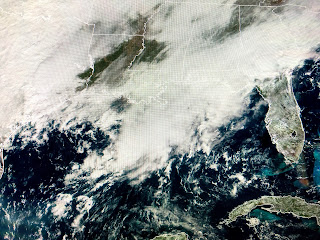
Climatologically speaking, October is our driest month...but not this year. As of the noon hour, the official total in Kenner is 10.78" placing us as the 2nd wettest October going back to 1946.
We may not have any heavy rain around right now as storms are to our west in Texas and to our east in Florida & Alabama. However, a cluster of storms has formed south of the Louisiana coast with a small low level swirl/circulation (see arrow) evident just west of these storms. If they move northward late this afternoon and evening, we could easily pick up 1-2" additional rainfall which would move us very close to the wettest October of 1985. That was the year Hurricane Juan wandered off our coast for several days.
The other big story is the early winter-like cold that covers the Rockies and Plains. A snowstorm may give Chicago several inches tonight & tomorrow...and it's only October! At midday, many cities are still in single digits. Burr!
Some of that cold will reach us on Thursday making for a very chilly Halloween for the Trick or Treaters. The weekend looks dry but chilly with highs in the 50s & 60s and lows in the 30s (Northshore) and 40s south. Get ready for sweaters, jackets & heavy coats. Stay tuned!


No comments:
Post a Comment