Morning lows ended up right on the forecasts from last night and many locations dipped to freezing and below, including parts of Metro NOLA. MSY stayed above freezing but (thanks to Zack Fradella's research) that was colder than anytime all of last Winter!
Thankfully the low clouds that hug our coastline will move back over us tonight keeping us well above the freezing mark. Those clouds are part of an upper disturbance that will bring us some cold showers during the day on Thursday.
The coming warm up will be painfully slow as much of south Texas remains in the 40s. Even with sunshine on Friday, highs will struggle to reach the mid 50s. The weekend should slowly warm back to 60+, but that is well below normal (72) for mid November.
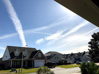
Finally, I took this picture of the sky with all the "contrails". It's not as pretty as the one I found on the internet.
There are still some folks who believe these are "chemtrails", chemicals released by various governments to poison us. If you really want to know what they are, Goggle CONTRAILS and read that they are CONDENSATION TRAILS from high flying aircraft engines, nothing more. Now back to the important stuff...LSU goes to Oxford & the Saints go to Tampa. The weather should not be a factor in either location. Stay tuned!


No comments:
Post a Comment