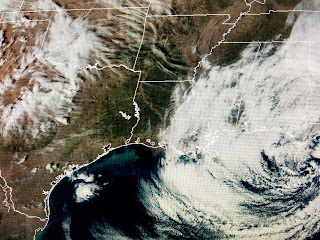
Unless you are traveling to the mountains or the northern tier of states, we can only dream of a White Christmas.
Temps are in the 40s & 50s from Boston to Buffalo, Cleveland to Chicago, St. Louis to Denver with no snow on the ground nor none expected during the next 48 hours. In fact, the only places with nasty weather are Florida & Southern California. Florida has been on the "wet side" of a well defined upper low that Zack Fradella said looked like a summer hurricane, but was "warm cored". If you looked at satellite pictures, you can see the circular pattern of the clouds, but the lack of any T-Storms around the center that is now just NW of Tampa.
As this system continues to march to the east, clearing skies are beginning to show up and, after 4 days of the uglies, we'll see the sun back tomorrow. That will make us warmer as you can see how Texas is 65-70 with sunshine.
You cold weather freaks shouldn't despair as models continue to show a much colder pattern returning for New Year's Eve and the first 1-2 weeks in January. This is still plenty of super cold air in Alaska and Canada and all it will take for that to come back south is the return of an east coast upper trough.
I see that happening the first week in January so we'll have some time to watch and prepare for it. Until then, let's enjoy a nice stretch of mild weather for Christmas week. Stay tuned!


No comments:
Post a Comment