The line of heavy T-Storms with strong winds is now east of NOLA taking the severe weather threat with it. The Mississippi Gulf coast still has that threat until the line blows to your east, which should happen during the next 90 minutes. Behind the line only some lighter showers with some thunder, but the strong wind & tornado threat is over for NOLA.
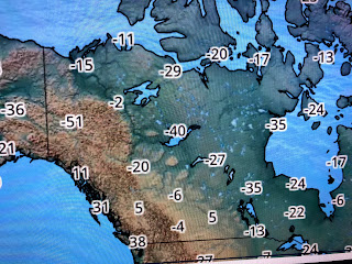
This afternoon will be cooler and drier, but the real cold will stay to our north for now. As I have been mentioning in previous blogs, super cold air (40-50+ below zero) lingers in Canada, but some of that chill is being drawn southward with our current storm system.
Notice Fargo is 20 below, Minneapolis zero and Green Bay 19. Long range models continue to hint that an east coast trough will develop and that would mean much colder air in Canada will invade the lower 48 for the second half of January. Far too soon to know if the trough will be deep enough to allow the Arctic cold down to us, but we likely will see several freeze threats later this month. For now, we can be thankful the line of storms had more bark than bite. Will update later this afternoon. Enjoy you Saturday & Sunday. Stay tuned!


No comments:
Post a Comment