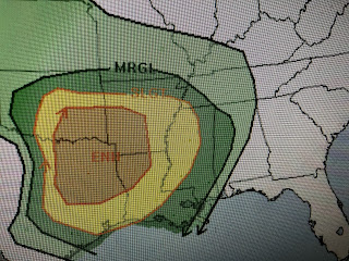
We remain in a weather pattern that has fast moving upper disturbances sweep into the west coast, cross the Rockies and then plow across the Gulf South. Already SPC is indicating another round of severe storms are possible here Wednesday night into Thursday.
Tomorrow's threat will be to our north and west with the threat on Thursday to our east. That tells me our best chance for severe storms here will come after dark into early on Thursday. I remind everyone they need to have the FOX 8 Weather App on their cell phone with the proper settings that will wake you up during the night in case a warning is issued for your location.
Today is beautiful with lots of sunshine and warm temps and OK humidity. You can see the return flow of moisture and clouds back over south Texas. As the surface low pulls out into the central plains Wednesday, we'll once again be in the warm air sector. As the upper energy approaches, showers & T-Storms will break out and head over the same areas as the past two systems.
Water Vapor shows that swirl over northern Arizona, but not much is there yet on the regular satellite view. I suspect Texas and Oklahoma will begin the action early tomorrow with the storms spreading eastward during the day. Again, I feel our better chances for strong/severe storms will come after dark into early on Thursday. SPC thinks we need to pay attention to this next disturbance and so do I. I'll be watching FOX 8 tonight for the latest updates. Stay tuned!


No comments:
Post a Comment