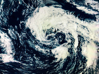
With one day left in May, there still is a chance (40%) that a large circulation well east of Bermuda could get a name, but NHC lowered those chances from yesterday. Even though there is a well defined large circulation, there is an absence of T-Storms plus there are several smaller swirls inside the large main swirl.
Our focus should be on the southern Gulf for next weekend as computer models continue to hint that's where the "C Storm" might form. The Euro even has outlined an area over the southern Gulf where development might happen.
Right now, NHC is watching an area of circulation in the Pacific that has gotten better organized and is likely to become their first named storm soon.
Some tropical moisture is streaming northward from that disturbance into the central Gulf and we'll have to see if anything happens in the Bay of Campeche for late next week. In the mean time, a weak frontal boundary is trying to push through us bringing drier air for Sunday into early next week.
Even though we have topped 90+ again, dew points are in the 50s & 60s so it doesn't have that real summer fell yet. A few showers have bubbled up, but they haven't lasted very long. The next 3 days look to be mostly dry.
Finally, when it gets really hot, it doesn't mean you can't look spiffy in the heat. My grandson Ethan looks like he belongs in Hollywood. He's ready for Summer. Hope you are too? Stay tuned!


1 comment:
Such a cutie
Post a Comment