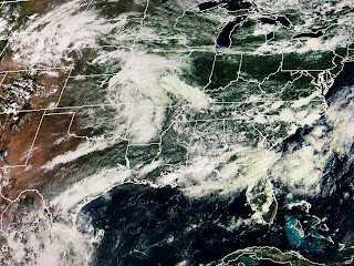
With a WSW flow over the northern Gulf, any tropical system will be turned east well before it gets near us. An that is what the latest track info from NHC indicates.
The top graphic is the centerline forecast from this morning while the one below it is the 4 PM advisory. Note the shift back to the east ending the westward trend from earlier. NHC does caution us to be aware that these fluctuations can be expected until we have a well defined center, which hasn't happened yet.
There remains a large/broad center of rotation with what I see as several inner lows rotating around the broad low. Recon aircraft still cannot find a closed center at the surface so they are not naming this disturbance yet. Additionally, NHC has lowered their intensity forecast which is good news. RIGHT NOW, this continues to be someone else problem down the road. We'll keep watching it.
Locally, we saw far fewer storms around today and that trend should continue into the weekend. We could use several dry days as the grounds are totally saturated from 5-8" of rain this week. I'll be out fishing tomorrow so I won't post until late. Stay tuned!


2 comments:
Thanks Bob. I hope that you are right!
thanks bob always looking forward to what u think and feel on the weather
Post a Comment