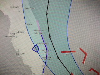
Even though Hurricane Isaias briefly weakened over night, recent satellite views suggests the inner core is regaining organization and should resume getting stronger this afternoon.
Since the latest computer model runs bring the track farther to the west, NHC has issued a Hurricane Watch for all of Florida's east coast. The new NHC track forecast still keeps the centerline track just east over water, but any further shift to the west would result in having the eyewall impact the coastal cities north of Miami.
So what will help Isaias make the turn to the north? The thinking is the same now for the past 2 days. Models continue to deepen a trough over the eastern states creating a strong SW shearing environment across the northern Gulf . As the trough shifts eastward, it should pick up Isaias and recurve it to the north and then NE. The real question is how soon? IF not today, then the hurricane threat to SE Florida becomes greater .
The top graphic is the 18,000' winds for Sunday morning. Note the 20-30 knot flow across the northern Gulf. This digging trough will also bring a front down through us by Sunday. No it won't bring cooler air, but it will bring lower dew points/humidity.
Finally, NHC mentions 2 other systems way out over the Atlantic that have very low chances (20%) for development. Bottom line for us is we enter August with no signs of any tropical threat for the Gulf during the next 7-10 days. Stay tuned!


1 comment:
Thank you for continued coverage! My daughter lives in Florida and this Louisiana girl needs to hear about it from our trusted meteorologist.
Post a Comment