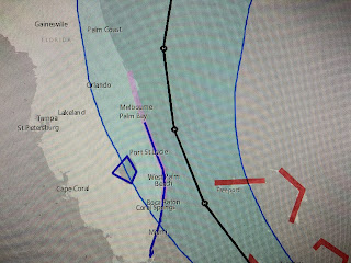
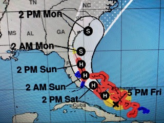
In my last post, I indicated Florida's east coast was not out of the woods regarding Hurricane Isaias. With computer models continuing a westward trend, NHC shifted their official track back farther to the west bringing the center line track with a landfall near West Palm Beach.
The top graphic is the previous center line track with the middle being the latest. The Euro model bring the center even farther to the west of the NHC track. Let's be clear here. Isaias is NOT Hurricane Andrew or even Katrina in terms of strength. He is not expected to be a Cat. 2 as earlier predicted but should remain a strong Cat. one. The worse side of the storm will be to the east, however, some of the eyewall winds could make it to land.
Satellite views show Isaias is a small, compact storm. It still has several clusters of storms away from the main center and that might be why he hasn't gotten stronger this afternoon. I expect we'll see some strengthening over night before reaching land on Saturday. While looking at a close up view of Isaias, you could see a large cloud shadow ( upper arrow) from a T-Storm west of Miami with the bottom arrow being the center of Isaias.
Mother Nature always is beautiful if you know where to look. Tomorrow being August 1st, I'll go over my thoughts regarding future evacuation during Covid-19 IF a storm threatens us.
Finally, have you ever heard of "Top Hat Begonias". Neither did I until this year. My friend Pete Perion suggested I try some and wow, what results! Their flowers and leaves are huge compared to regular begonias. I'm sold on them and will try to get them through the winter since they're in pots. Next year you might try them in your yard,
Tell your friends in Florida & up the east coast not to freak out. The media will go full out on this Cat. 1 Hurricane. Listen to your local leaders and you'll be fine. Stay tuned!


No comments:
Post a Comment