This is a quick tropical update. As I mentioned yesterday, it appears the MJO will swing into the favorable phase (rising air) over our part of the planet during the next couple of weeks. NHC keeps increasing the chances for development for two systems they're following.
Which one will become our next named storm (Laura)? The closer disturbance is now over the eastern Caribbean and NHC gives it a 60% chance to develop.
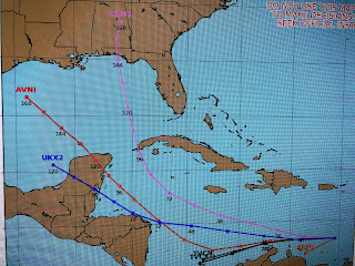
Both the Euro & GFS take it as a small storm into the Texas coast for early next week. However, the Canadian model brings in northward into the Gulf. RIGHT NOW, this will be the weaker of the 2 systems. Sp[eaking of 2 systems...
Back out in the Atlantic we have 2 clusters of storms. NHC is focusing on the first cluster and computer models track it farther north than the first system. I'm more concerned about this second system than the first, but it's way too early to start speculating where it might go when we don't have a closed center yet. Regardless, we're likely to be tracking 2 named storms later this week into next week and you need to finish your preparedness (stocking supplies) this week.
This is my concern regarding the Flip of the MJO. Look at Hurricane Genevieve in the Pacific where the MJO is in the favorable phase. Go back and look at yesterday's blog to see how she looked as a Cat. 1 Hurricane compared to this morning's view as a Cat. 4. In meteorology, it's called "rapid intensification" and I'm afraid that's what's ahead for us during the next few weeks in the Atlantic. Let's hope and pray they stay away from us. Stay tuned!


No comments:
Post a Comment