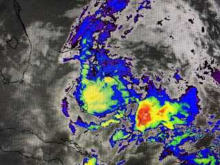
Based on satellite loops this morning, Hurricane Isaias just doesn't look like a Hurricane. Sure you can see some rotation, but he remains very asymmetric (Lopsided) with all the storms removed east of his center. In fact, look at the colorized pic showing the brighter (colder) cloud tops are NOT with the Hurricane!
Even the radar presentation looks poor with no eyewall apparent. NHC has lowered the intensity, but they believe it'll be back to an 80+ mph storm once it gets back over the Gulf stream. This close to land, they normally won't change their center line forecast track just for continuity sake.
So far Isaias has been a well behaved system with no wobbles or loops and NHC expects that to continue. The way I see it, IF the storm stays this lopsided and IF the center line track proves correct, Florida will only get a glancing blow with minor impacts. Probably the worst impact will be beach erosion since Isaias is predicted to be a slow mover. He's something to watch as he's not our problem. His track up along the East coast into next week will bring them some needed rainfall.
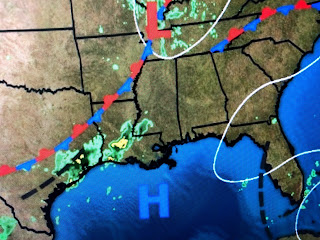
Back to our weather, relief is so close yet so far. Temps are in the 70s under the clouds and showers to our west. Dew Points have dropped into the 50s & 60s in Texas. If only that front could keep moving!!! Well based on what I said last night, I still think it'll make it , but not until Monday.
The top graphic is the forecast upper winds for Monday while the bottom is the satellite pic showing the frontal boundary. Once Isaias gets to our latitude (30 north) on Monday, his circulation should help driving down some of that drier air off our coast making for a very pleasant Monday-Wednesday of next week. it'll still be hot, just not as humid.
Finally, NHC is watching two areas out over the Atlantic. The one off of Africa is TD # 10 and they don't expect that to become a named storm. (Oh why not!) The system over the middle of the Atlantic is forecasted by models to become TS Josephine in the next 2-3 days. It will recurve and never impact the U.S. Stay tuned!


No comments:
Post a Comment