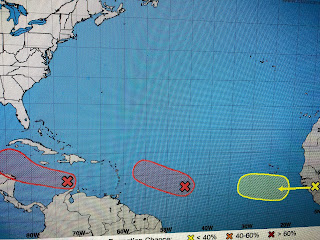
I'm late on posting because I was out fishing today. More on that in a later post. Not a lot of new information regarding our two potential tropical systems, except to say NHC keeps increasing the chances for development.
It appears to me the system (98L) out in the Atlantic will be the first to be named as a burst of T-Storms has developed close to where the center of rotation might be. However, we have many days to follow this development. Looking closer to us, the system in the central Caribbean is trying to get a rotation as it heads to the west.
The color(infrared) satellite view shows disorganized storms unlike the one out in the Atlantic. This afternoon model run has shifted the threat for 97L northward into the central Gulf. Should you believe them? I don't since we don't have an initialization point yet. Let's wait until we have that (Tropical Depression) before we start to worry. All models keep whatever forms as a weak Tropical Storm, but you shouldn't believe that either..
Some drier air (lower Dew Points) snuck into SE LA today, but you probably didn't feel it as our high was 95. Look at Texas with DPs in the 40s & 50s!
Finally, the western fire season has exploded with the smoke from the Colorado fires spreading southward into NM 7 AZ. while California is covered in smoke. Seems most of the fires were started from lightning strikes. They need our prayers. More on the Tropics tomorrow. Stay tuned!


No comments:
Post a Comment