


NHC is still keeping the max winds at 60 mph, but that's only over a small area. They agree it has weakened and that is reflected in their intensity forecast that does not make this a hurricane. Here's the 10 pm updated track.


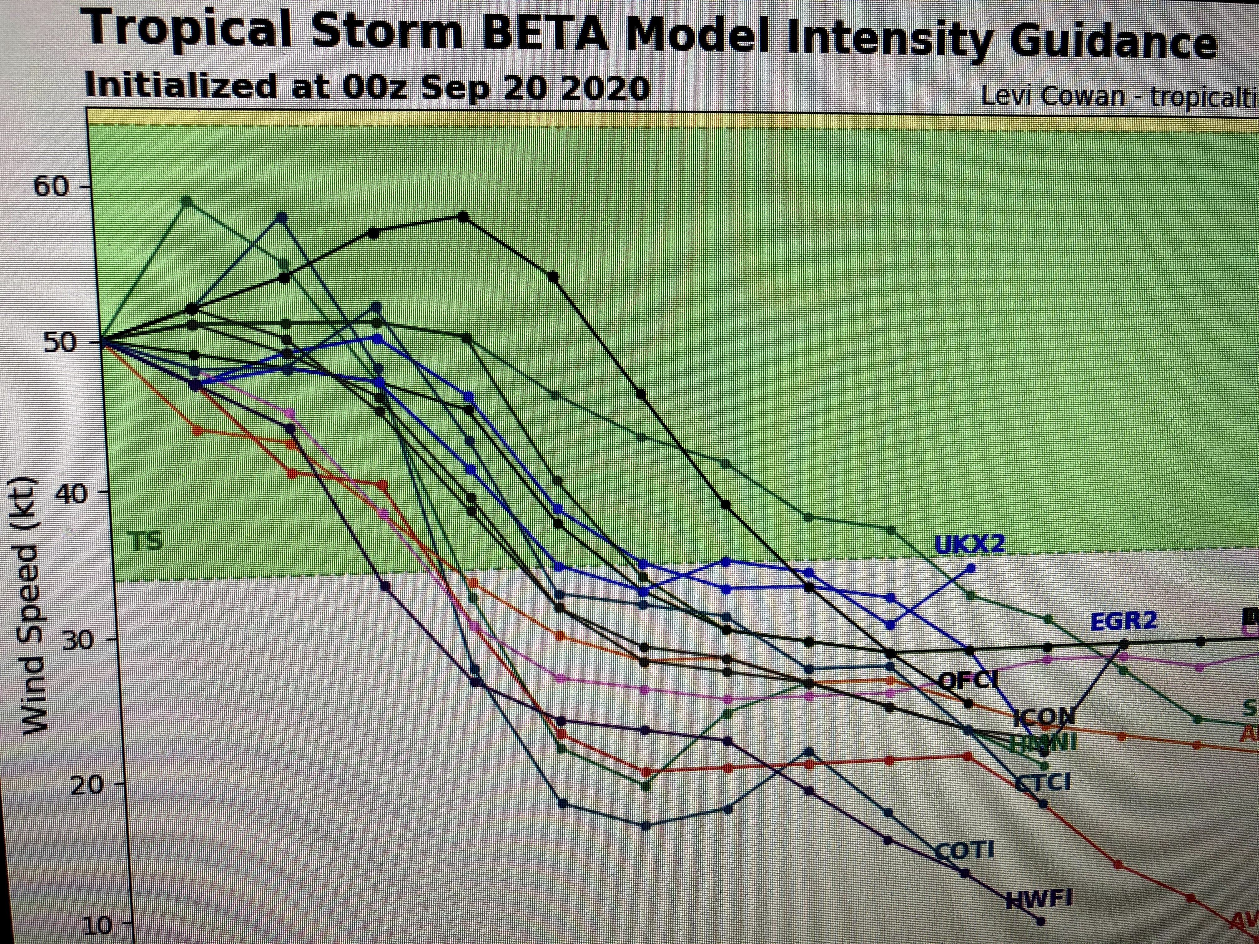
Even though Beta's current motion is NNE at 2 mph, all guidance indicates it must turn to the west. Plus look at the intensity guidance that really weakens it to a weak Tropical Storm or even a Depression as it nears the Texas Coast. So what will make Beta go west. As I explained on an earlier post, Hurricane Teddy could be a main reason as he moves up the east coast blocking the exit of a large, cold surface high over the northeast. Take a look at what is now and what the GFS model predicts for next Tuesday.


Since our surface pressures are going up, that tells me Beta can't push out the building high and must move to the west. More importantly, look at the drier dew points that are being drawn into Beta.


Our gusty winds are more the result of the interaction between Beta and the large surface high over the Northeast. I know many of you have mentioned that the models have been worthless during Sally & now with Beta. Just remember with Sally, we did NOT have the amount of cooler and dry air surrounding her. The environment around Beta is far more hostile. Even IF the models are totally wrong and Beta continues coming our way, it is not much of a storm. Tropical systems thrive with a warm, moist environment around them, but that is not the case tonight. I'll probably not post again until after the 10 AM advisory tomorrow, unless something strange happens overnight. Stay tuned!

14 comments:
So yesterday Bob said he just couldn’t believe NHC track for Beta. That’s it still no explanation why or what his “track” is. This is all he does questions and bash other meteorologists but won’t give his “forecast”. Well so far this unbelievable track as he says has been spot on. Fail (again)
Thanks, Bob. I find your blog informative. Ignore the haters.
What part of this forecast don’t you understand ?
“Since our surface pressures are going up, that tells me Beta can't push out the building high and must move to the west. More importantly, look at the drier dew points that are being drawn into Beta.”
I watched bob Breck growing up and 99% of the time he was correct with the forecast. I appreciate what he did for
the community until he retired a few years ago and what he still does. Thanks bob Breck for keeping us informed though the years and still taking the time to keep us informed because unlike the weather channel bob Breck does not overhype the community and tries to explain
in thorough detail what is going on.
So Why Are You On Here Reading His Thoughts? Get A Life!!
I trust Bob. He has no agenda. He is beholden to no one. He gives his expert analysis at the behest of no masters.
I trust Bob. Period.
Anonymous why do you come on all bobs post talking shit ? We all know your an old weather guy that no longer has a job and no one reads your blog 😂
Tropical storms and hurricanes, you never know what they gonna do til they do it, period! Bon is a blessing to those of us who follow him! No one is FORCED to watch him! We CHOOSE to watch him!
You people saying Bob is the greatest and he does nothing but show you what the NHC forecast is. Bob, for once take a risk and just tell us if you agree with that forecast or not
LOL that’s has Beta following the NHC track which Bob just said Friday he found unbelievable. That’s for making my point. You rock.
Sure he does just did it with this storm showing a model that has been unreliable this year (his words not mine) taking Beta has a major hurricane close to New Orleans. Ugh yeah hype
Bob acts like he knows what they are going to do well when they are 24 hrs from landfall anyway.
Why all the storms that came out of Africa turned out to be fish storms?!
Post a Comment