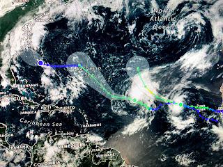
While the Atlantic ocean currently has 2 tropical storms churning, with a third or 4th not far behind, the areas we watch for Tropical Activity (Gulf & Caribbean) remain quiet.
Paulette is ahead of Rene, but both systems are predicted to turn to the north and stay away from land. Another strong wave moves off of Africa tomorrow and that is expected to become Sally. Yet another wave follows that so the wave train continues as typically happens in early September. Closer to home, an area off the east coast still might become a depression as it nears the Carolina coast tomorrow.
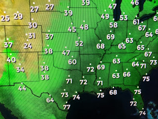
So far development has been limited as the MJO is in the unfavorable (sinking air) phase. Back over the states, a real cold front has pluhged down over the Rockies all the way into western Texas.
Look at the temperature drop behind the front. Dallas is 82 while Amarillo is 42! The 24 hour temperature drop in Denver (92 to 31) of 62 degrees is the third highest in recorded history that dates back into the 1800s. Alas, the cooler air will not make it here, but it will get close. We'll have to wait another 10-14 days for any real front to bring us relief.
Finally, the huge upper low over the Rockies has blown the smoke plume well out into the Pacific. Coastal California still is socked in, but much of the rest of the West has cleared out temporarily, as many fires are still burning. A wind shift will quickly bring the smoke back. September 9th 1965 is always a special anniversary here as Hurricane Betsy smashed into SE LA/MS. Thankfully we have no Betsy to watch around us right now. Stay tuned!


2 comments:
Would a storm that had already developed in the Atlantic be inhibited by moving into the sinking MJO zone in the Gulf?
Bob, I was born during Hurricane Betsy!
Post a Comment