If you look at temperatures, you can't find a front. If you look at dew points, hard to believe a front has moved through since our DPs are still in the 70s. Perhaps it's the northerly winds? Yet temps. are 90+
Models are still forecasting a deep trough, but now the axis of the trough is not over the eastern states but farther west over the central states. That means the strong front that does develop will struggle to push through us with the core of the cooler air staying to our west and north. We still expect slightly cooler temps & lower humidity so keep hoping Gang, The Tropics are supposed to heat up as NHC is watching the far eastern Atlantic and now have included the Caribbean with an area to watch.
IF Paulette were to form, the Euro tracks all take the system to the north curving long before reaching the U.S. My thinking is we need to keep an eye closer to home.
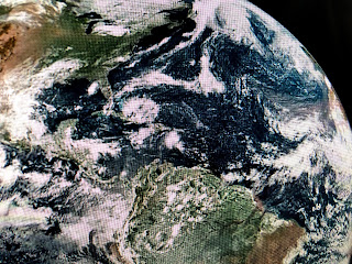
The main player here is an upper low over the eastern tip of Cuba with a small surface low in the Caribbean south of the Dominican Republic. The upper low is producing wind shear making any surface development unlikely. The Gulf is quiet this Labor Day weekend.
Finally, I've been highlighting some of the colleagues I've worked with over the decades. Once of our last tracking charts featured Chris Franklin, Nicondra Norwood , the little fella & Bruce Katz. Chris has moved over to Ch. 4 while the other 3 are still with FOX 8. In the coming posts, I'll feature several of my competitors over the years. FYI, several models are hinting a major hurricane will approach the east coast of the U.S. in 10-14 days. That's a long way out & the system models are picking up on is still over Africa. Lots could happen , but the MJO remains in the unfavorable (sinking air) phase. Next update Sunday PM. Stay tuned!


1 comment:
Bob,
As a 70 year old New Orleans native, I've seen a lot of TV Meteorologists.
I remember when you first started here. It was Great!! Thanks to you and Fox 8,we've had and still have a great group of them. I can't help but believe that your influence had a lot to do with that.
Thanks Bob.
Post a Comment