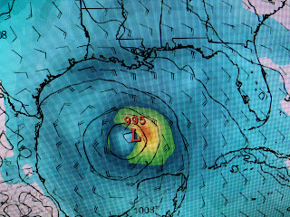
That pretty much follows the guidance coming from the American model. The second graphic is the GFS position for next Friday morning. As you can see, that means Gamma will be another slow mover.
So while TD 25 is expected to become a Tropical Storm, The interaction with the Yucatan will hinder its short term development. However, look farther to the east south of Puerto Rico. That is another tropical wave that the Euro model develops more than TD 25 and brings it into the southern Gulf 10 days from now.
This graphic is for Monday Oct. 12th. The Euro then brings it NE towards the Florida coast near where Hurricane Opal struck back in 1995. If you remember, Opal became a Cat. 4 over the southern Gulf before weakening to a Cat. 1 after encountering cooler waters and stronger wind shear before landfall.
But, as Lee Zurik says, there's more!
Far out in the Atlantic is yet another swirl that could become a named storm. So after a quiet 7-10 days, the Tropics have kicked in up a notch(sorry Emeril Bamm!) trying to get beyond the 28 named storms of 2005. But for us, cold fronts will be our friend this weekend into early next week.As you can see, this morning's front has pushed deep into the Gulf with very dry air (dew points in 40s!) over us. Another weaker front will slide through late Sunday keeping us in the feel good air into next week. Reading the comments, it almost seems there are some of you who almost want a Major (Cat.3+) to affect us?
I think I explained why The Lady sang last night. But check the above graphic I just snapped of Zack Fradella on FOX 8 at noon. The Oceanic Heat Content/Energy Potential over the northern Gulf is way reduced by recent cold fronts and hurricanes. Even IF we see a major Hurricane develop down over the southern Gulf or Caribbean during the next several weeks, it will weaken as it moves over the cooler waters to the north. Read all the gloom & doom bloggers if you so choose, but please don't spread the rumors on my site. Remember what a late Mayor of New Orleans once said..."don't believe any rumors unless they come from me"! FYI, the Recon plane ran into engine troubles and had to turn around. Next update after 4 PM. Stay tuned!


No comments:
Post a Comment