Well that forecaster is joining me in a well deserved retirement and I salute him. He earned my trust and yours over the years by being correct time and time again. His full story earned him front page coverage in today's Advocate and I wanted you to know another weather legend has retired. Well done Robert!
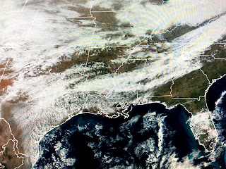
Yesterday's storm that dumped 4-5" on Green Bay (they gotta lose to Da Bears!) has pulled out into eastern Canada. You can see how much warmer we are on the backside of high pressure. Those fronts to our north will stall as a complex series of storms out west head our way for late this week.
You can see some clouds inland over SE LA/MS, but the deep moisture from the Gulf is not apparent in satellite views just yet. The big dip/trough over California will be our next weather maker with highs in the 70s through Thursday before the big cooldown arrives for the New Year.
Note how the models are bringing out the upper energy as several waves. The top graphic is today's upper flow with the system over California. The next is for late Wednesday and look at how far south it is. That might trigger a severe weather outbreak for us on Thursday so we'll need to pay attention. The next graphic has a secondary upper low following the first one Late Thursday with the bottom view being valid for Friday afternoon. All in all, expect to see some nasty weather for a good part of the lower 48 into this weekend.
Storm number one is giving snow to the Rockies with light rain falling across southern California. Denver is in the 20s with light snow. the bottom pic is my son's (Rob) backyard in Longmont, CO and it appears he's had about an inch so far. If you have any visiting relatives that will be driving back home up north later this week, make sure you alert them to the likelihood/potential for some serious snow & ice making driving conditions difficult & dangerous. Parts of Iowa, Nebraska, Kansas & Wisconsin could receive 6-12"+ totals. Even Chicago will get some snow with the first round before turning to rain for the second disturbance. I'll update that in future posts. Stay tuned!


No comments:
Post a Comment