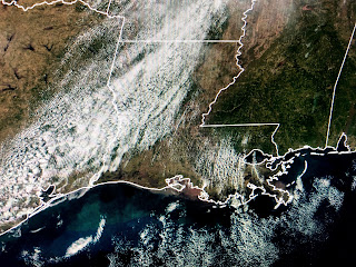
You can see when fog enters the forecast for Tuesday morning as dew points recover above 60 degrees. The surge of warm air will have us way above normal for the next 4 days with the possibility for some strong storms with our next front on Thursday.
The last couple of snowstorms have taken a track far to our north and that leaves us and all of the Southeast above normal/average. That will change when our New Year's Eve storm forms farther to the south.
The top graphic is today's upper air flow with the one below it valid for New year's Eve. Note the feature over SE Texas that should trigger/develop quite a rain/snow storm. We'll have to watch whether severe storms threaten us on Thursday. The next graphic is valid for Jan. 10th and indicates January is likely to be a very cold month for most of the nation. There is still plenty of 20-30 below zero air up in Canada.
As south winds bring back the low level moisture, skies will not be as sunny as the past several days. Our next rain chance won't happen until Wednesday into Thursday. I've got my plants back outside to enjoy 3-4 days of mild temperatures. Might have to bring them back into my He-Shed before next weekend. That's what happens in Winter. Stay tuned!


No comments:
Post a Comment