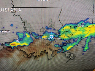
However, I'm seeing some indications that the heavy band of rain that was south of NOLA before dawn is weakening as it pulls to the north. In fact, we could see some sunny breaks making for a better afternoon.
There is another band of storms well offshore that we'll have to watch, but I'm hoping that pulls out to the NE and stays mainly offshore. Radar is showing a weakening band of showers that is lifting to the north. I expect many more dry hours today compared to yesterday.
As one upper disturbance moves away over Wisconsin, another strong system gets ready to head into the Plains from the Rockies. That next system already has SPC on high alert for tomorrow.
The bullseye level 4 risk is far to our north, but we could see some strong storms with the cold front late in the day. Since those storms will be fast moving, I don't expect a flood threat from them, but more a threat for damaging high winds. We'll need to keep paying attention. Next update later today. Stay tuned!


No comments:
Post a Comment