4-6"+ totals are very likely along with the possibility of severe weather. The bottom graphic is from SPC indicating the concern for some strong storms during the next 4-6 hours. The real/higher severe weather threat comes on Thursday with the greatest risk north of Lake P.
The top graphic is valid for today, the middle being valid for Wednesday with the bottom one valid for Thursday. A slow moving cold front over east Texas is the cause for all these problems. An upper trough covers the western states producing an upper SW flow that will stall the cold front.
The bottom graphic shows the dew points that are creeping into the 60s indicating low level moisture is increasing.
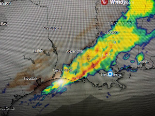
The band of heavy rainfall across Louisiana is way ahead of the surface cold front. The northern part of that band is moving eastward while the southern part is slowing down. Lake Charles received 5+" as the band went through earlier this morning.
The heavier rains will reach the South Shore after the noon hour and you will need to limit travel later this afternoon as some streets are likely to flood. There are wind gusts with this line 40+ mph that might cause some power outages? Be prepared & aware for an extended period (4-8 hours) of stormy weather. We're likely to see rainy periods lingering into Thursday with another round possible over the weekend.


No comments:
Post a Comment