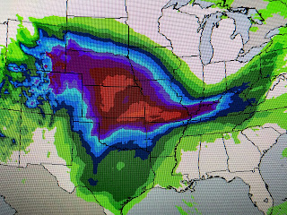
The slow moving upper low remains just off the California coast, and as it begins heading to the east there will be a snow storm to the north with some severe weather potential over the South.
SPC has a slight risk for severe storms across the Texas panhandle & western Oklahoma tomorrow. With the frontal boundary stalled from the Plains into the Ohio Valley, there is the possibility for heavy rainfall (3-5+") farther to our north.
We will stay in the warm air sector through the weekend with most of the rain staying north of us. We'll see the front get close by Monday increasing our rain chances for much of next week.
Not only have our temperatures warmed up, the low level moisture has also increased with dew points 60+ surging into Arkansas.
For planning purposes, this weekend looks warm and mostly dry with next week looking much wetter. The models do bring colder air back towards the end of next week bringing back the need for sweaters & jackets. Until then, enjoy the warm Spring feel. Stay tuned!
For planning purposes, this weekend looks warm and mostly dry with next week looking much wetter. The models do bring colder air back towards the end of next week bringing back the need for sweaters & jackets. Until then, enjoy the warm Spring feel. Stay tuned!


No comments:
Post a Comment