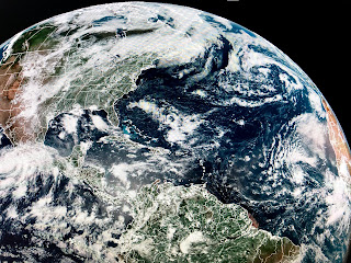
The Hurricane Hunters will be out early tomorrow and we could be watching Danny approach the Carolina/Georgia Coasts on Tuesday. 96L will stay out of the Gulf. The rest of the Tropics remain active but nothing is in the Gulf that could develop.
That swirl off the lower Texas coast is an upper air low that will move inland tonight. Hurricane Enrique is on the eastern Pacific while 95 L still is way out in the Atlantic.
Nationwide, the West Coast is blasting heat records as they're under an upper high. Models are developing a deep trough over the eastern states later this week that will bring down much cooler air from Canada for the July 4th weekend. Don't think it will reach us, but would that be nice?
After a mostly dry Saturday, today has been much wetter. This week looks to be basic summertime with heat, humidity and daily spotty storms.
Finally, this article was in yesterday's paper. Note what it says about producing more water vapor. My understanding is the greatest greenhouse gas (by volume) is water vapor. Humm? But there's more (Lee Zurik)
It is a daily bombardment of articles trying to scare us into accepting the coming restrictions government will impose on us to save our Planet. Blame everything on Climate Change. Well, not everything. I did find this article.
It is a daily bombardment of articles trying to scare us into accepting the coming restrictions government will impose on us to save our Planet. Blame everything on Climate Change. Well, not everything. I did find this article.
I looked for any mention of Climate Change, but found none. My question is...who funds all these studies? Do we really need to know that women drink as much as men? Silly. Stay tuned!


No comments:
Post a Comment