The top graphic is the GFS valid for next Saturday morning with the bottom being the European model at the same time period. One thing to note is neither make whatever forms into a big storm. What is more likely to happen is a tropical depression will form down over the Bay of Campeche and drift to the north bringing a surge of tropical moisture/rainfall. The 7 day rain totals hints a tendency towards the Florida beaches.
So as I mentioned yesterday, NHC is looking at 2 areas for possible development. They have raised the probability in the Gulf to 40% with the Pacific disturbance the same 40%. That tells me they are not very confident yet in future development. Here's what I think will happen.
I highlighted 3 areas of low pressure. The one over the Yucatan appears to be a weak surface low with the low south of central America another weak surface low. The Low in the Gulf is a mid to upper level low moving to the west following the circulation of a large upper high centered in Texas. That upper low should move westward and not be a factor. The other two surface lows will meet/merge over the southern Gulf by Monday and that should allow NHC to designate it as an Invest. They then can begin running computer models (Spaghetti) giving us a better idea on future motion. Until then, it's silly to speculate where it will go and who gets the main impacts. At this time, the main impact should be heavy rainfall and not wind or storm surge. IF a storm forms, it will not be an "evacuation type" storm. Tomorrow I'll get into how you decide whether you stay or leave when a big Hurricane threatens.
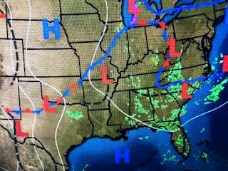
Today is another Sunny, dry day with highs climbing well into the 90s. There is a northerly upper flow as a large trough covers the eastern states. Your can see most of the clouds and storms are to our north and east.
It actually is a convoluted looking surface map with weak frontal boundaries and numerous areas of low pressure.
Where it's sunny, it's hot and where it's rainy, it's not. Dew points are into the 70s over many of the southern states making it feel real tropical. That isn't likely to change. In fact, until or if a Gulf system moves northward, the next 4-5 days see little change.


No comments:
Post a Comment