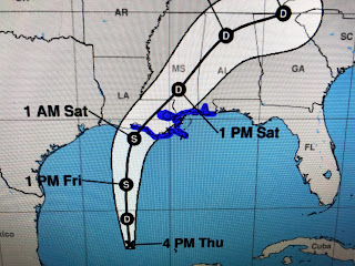
The top graphic indicates storm warnings from west of Morgan City to the AL/FL line. The next graphic is the NHC forecast track/cone followed by a close up of the centerline. The bottom graphic is the expected storm surge which should not cause any problems inside the levee protection system.
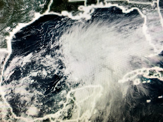
This will be a very lopsided system so where the centerline track goes will be very important. RIGHT NOW, NHC is taking it to our west putting us on the wet side. If we can get a track shift to the east of NOLA, our totals will be much less than currently predicted. The top satellite view has all of the storms over the eastern Gulf. The next view is the water vapor showing the upper low (arrow) over the western Gulf. The bottom is the wide radar view with most of the rain echoes over the southern Florida coast.
You can see NWS has 6-8" covering most of the metro area including even more for the Mississippi coast. Winds there have turned to the south while ours remain mainly easterly. I'll be watching to see if our winds become southerly as that will tell me this potential storm will go to our west. My gut tells me these rain totals are way too high as this looks to be a fast moving system that doesn't stall out like some past flooding storms. Regardless, this does not look to be a great weekend to head to the beaches.
In fact, some wrap around moisture could linger into next week. This is not going to turn into some monster storm and still could just be an "inverted trough" bringing a moisture surge to the northern Gulf coast. Remember, any shift in that centerline track means way less wind and rain for us. I'll have another update later tonight. Stay tuned!


1 comment:
Thank you. We appreciate you!
Post a Comment