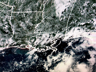
The arrows show the 2 systems with the one currently moving through the Islands as a Tropical Wave while the farther one to the east has hints of a broad circulation. NHC is expecting this to become Tropical Storm Elsa shortly and models track it westward through the Caribbean and over Jamaica into next week.
Kind of surprising to see NHC keeping the intensity under hurricane strength. Their track only goes out to 5 days but the GFS (American) model for NEXT Wednesday turns it northward into Florida. Way, Way too early to have any skilled idea on where this is going. In fact, it might turn sooner and NEVER reach the Gulf. Why? Look at the deep East coast trough expected to develop for Saturday morning.
IF this proves to be reality, the trough should depress the blocking high over the Atlantic back farther to the east allowing an avenue for soon to be Elsa an opportunity to turn to the north keeping her out of the Gulf. What I will be watching for is that turn because, if it doesn't happen soon enough (note the cone stretches into the Gulf at 5 days) there is the potential for Elsa to follow the GFS model track. Bottom line, this is not our problem for this weekend and perhaps never. Wait & watch.
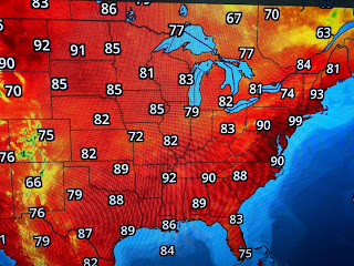
We can already see the results of that digging eastern trough as 2 pushes of colder air are coming out of Canada. Those fronts will break the current NE heat wave and give them a delightfully cool July 4th weekend. See how Louisiana humidity (dew points 70+) surges up the east coast. While the West, including south central Canada, is baking, very chilly air is plunging southward off of Hudson Bay.
So the question for us is...Will this cold front have enough push to move off our coast into the northern Gulf this weekend. Unfortunately, models say no with the front stalling near us meaning rain chances will stay well above normal. That will impact many outdoor plans (including fireworks) for this weekend. Let's hope models are wrong and the front pushes through.
The spotty storms bring brief relief from our summer heat. Florida was covered in storms this afternoon as a weak tropical wave heads to the west. Keep the rain gear handy the next 2 days and hope that we'll dry out Saturday PM into Sunday IF that front makes it through. Stay tuned!


1 comment:
AP...Just going back over old posts and noticed your comments. You are incorrect. I never said such words. End of story. You can go back over old post like I have, and if you find such a comment, let me know. Never said Elsa would threaten us. Thanks
Post a Comment