NHC shifted the center line track slightly farther to the east and that means the brunt of the storm will be east of Panama City.
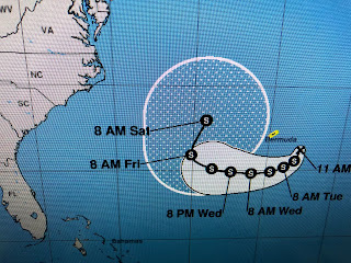
Elsewhere in the Tropics, Tropical Depression # 8 will likely become T.S. Henri later today. His track will keep him well east of the U.S. and shouldn't be our concern.
And that should be the same with TD Grace. She will likely become a tropical Storm later today as her circulation is going just south of Hispaniola and could approach Hurricane force before reaching the western Gulf late this week.
My son (Rob) asked me a good question. Why won't Grace make the curve to the north like most storms?
Shelby Latino showed us why on this morning's FOX 8 News. As Fred lifts to the north, the Atlantic Ridge will build in behind it at the surface. In addition, an uppper high will develop blocking any northward motion. Grace will not be our problem. We'll have a heat wave later this week due to that upper high. Stay tuned!


No comments:
Post a Comment