The 10 PM NHC forecast track hasn't changed and that means this will stay a Florida storm.
Monday will not be a pretty day along the beaches as heavy rains & gusty winds will make it dangerous to be outdoors. The rain totals have been reduced slightly, but some spots still can expect 5-10 inches.
The only impacts to SE LA?MS will be along the coast where tides will be 1-2' above normal along with gusty winds that will cancel any offshore trips.
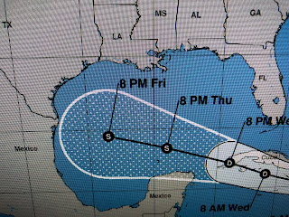
NHC is following 2 other systems tonight. The one north of the Bermuda could be our next named storm (Henri) as soon as tomorrow. Tropical Depression grace continues to struggle as it approaches Hispaniola. The forecast track takes it over the island tomorrow and NHC believes Grace will stay weak.
Computer models keep Grace weak until she reaches the southern Gulf. The new track has shifted farther to the south (away from us) and now aims towards the lower Texas coast. As I've pointed out before, since it is a weak disorganized system, don't take that forecast track to the bank. There likely will be changes down the road much like with Fred. For now, no storms will threaten Louisiana. Those of you east of Pensacola need to "hunker down" and expect power outages and possible tornadoes during a stormy Monday. Stay tuned!


No comments:
Post a Comment