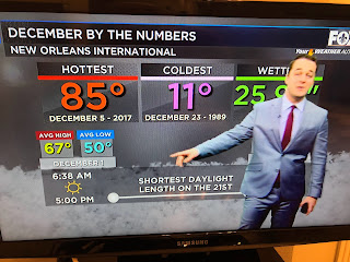
Today we are closer to the warmer extremes with no signs of a huge cooldown during the next 7-10 days.
The reason we're not seeing the cold is the result of the upper flow that has the trough over the Great Lakes, but not diving down into the Gulf. That is keeping all of the cold air far to our north and east while much of the lower 48 remains dry & very mild.
There is a weak front to our NW, but it doesn't have any cold air behind it. As southerly winds are back, the low level moisture (dew points) is increasing and NWS is indicating there will be lots of dense fog after midnight into Thursday AM.
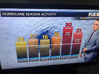
The seven day is indicating our next rain chance comes on Monday & Wednesday of next week. After being so wet this year, October & November turned very dry so we could use a good soaking. Finally, Zack had some terrific graphics this morning regarding the 2021 Hurricane season.
This was the 6th straight year of above average named storms, although we all recognize NHC is naming many weak systems that were ignored in their past history. What I'm hoping is a trend showing perhaps that we have reached a peak in activity and are on a downward trend for the next several years? We all know for the second year in a row, the Gulf was the focus of way too many storms. The AGW Alarmists are bragging..."see, see, we told you there would be more frequent & intense storms". However, Dr. Phil Klotzbach (Dr. Gray's successor) had an interesting statistic that makes one think Global Warming/Climate Change is not all black and white. The tropics, globally, have shut down for the past 2 months and one has to ask why? Could that shut down involve something else besides man? Something to think about. In the meantime, get out and enjoy this Spring feeling weather as December reality will arrive soon enough. Stay tuned!


No comments:
Post a Comment