Wednesday's dew point was 51, but today it has touched 70.
Some heavy downpours have developed to our west and they'll make for a wet rush hour. As a cold front approaches us by late Friday, SPC (Storm Prediction Center) has place a large area under a threat for severe storms.
The greatest risk is focused from the Arkansas/Louisiana border northeastward into Illinois & Indiana. For us, any severe threat won't come until after dark.
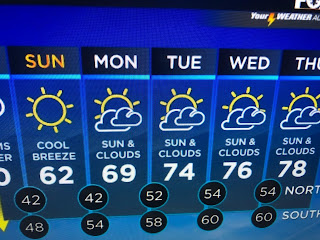
The western upper trough remains in place and that will keep any super cold air from coming our way. This weekend's front will get us back to where we should be with yet another quick warmup returning for most of next week.
There is still hope for you cold weather geeks. Look at the change in the upper pattern that models are forecasting. The top graphic is from today showing mainly a west to east flow. The bottom is valid for Dec. 21st bring a sharp trough over the Great Lakes and eastern states. That would finally bring us much colder air for Christmas week. But in the short term, the cooldown will be quick & brief.
Finally, look at this satellite view showing mountain wave clouds.
I love to find the unusual on satellite pictures. All you have to do is look around and you'll find something different. Stay tuned!


No comments:
Post a Comment