


The southern storm track (orange arrows) has not been active and until there is a dip in the northern track, we'll stay warm. Models are hinting dips are coming with a sharp one around Dec. 17th.


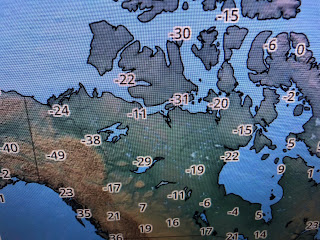
The top graphic is valid for Friday morning Dec. 17th. If that proves to be reality, it will drag the Arctic chill over Alaska & Canada down into the lower 48. There's some super cold (45-50 below) air up there so it appears the second half of this month will be feeling like Christmas.


The surface weather map has a Winter feel across the northern states while it's Spring-like across the southern tier. The front to our north will struggle to reach us on Tuesday and Wednesday, but it should be close enough to give us some rain chances. We'll warm back up for late week with the real cold front arriving NEXT Sunday. Watch for that flip flop from warm start to cold finish coming in the next 2 weeks. Stay tuned!

No comments:
Post a Comment