


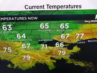
This will NOT be a heavy rain event as the main upper energy is far to our north. However, note how temps quickly tumble into the 60s behind the front.


This is a nice shot of colder air, but the core of the cold will stay far to our north and east. It won't last but a day as by Wednesday we'll begin a fast warm up that'll have us approaching 80 later this week.

Look at that roller coasters temperature ride the next 7 days! A stronger cold front plows through Saturday night into Sunday when we'll need the heavy weather gear once again.


We may get into some late afternoon sunshine on Tuesday. If not, temps will stay in the 50s which will be quite a temperature drop from today. You cold air geeks wanted it so don't complain as the second half of December will be significantly colder than the first half. Frankly, isn't that what most of us want for Christmas? That cold feel, the log on the fireplace. the hot toddy, the Christmas sweater. Trust me, in another week it will begin to feel a lot like Christmas, and all will be well! Stay tuned!

No comments:
Post a Comment