The top graphic has showers around us as soon as the noon hour with better chances during the afternoon. Rain chances stay high into next week with the bottom 3 graphics showing the models rainfall 7 day rainfall totals. The heaviest amounts (4-6"+) are over Texas and north Louisiana with 2-3" amounts around us.
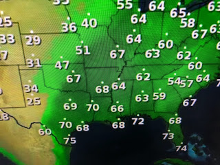
This is tropical moisture coming our way, but there are no signs of tropical development. Yesterday Denver was near 90, but look at today.
In fact, most of the western states are quite chilly with some severe storms possible along that boundary tomorrow as it sags closer to us. Don't get your hopes up for us seeing that chill.
So today's sunny skies will see more clouds and showers on Saturday with even more on Sunday.
There is a benefit to the clouds and rain as that should make us less hot as we head into next week.


No comments:
Post a Comment