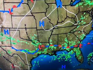
Texas is finally getting in on the rain and that means relief from the summer long heat wave. Houston is one of the exceptions as they're still near 100.
The North Shore received the heaviest rainfall, but my house had a quick 1/3 of an inch. We could use a lot more and tomorrow into Saturday should proved us several more opportunities for soaking rains.
If this frontal boundary remains stalled into next week, we could see some tropical moisture surge over the western Gulf into Texas and then Louisiana. That's why our rain chances increase again next week.
The MDE out in the Atlantic remains dead with the Caribbean and Gulf also quiet. The only system with potential is over the Yucatan and it is now invest 99 L.
Once over the Bay of Campeche tomorrow, it could begin to get better organized and a Recon plane is scheduled to investigate. Today's GFS does NOT have any disturbance in the Gulf for August 29th. All signs point to the tropical switch to flip after August 20th. Stay tuned!


No comments:
Post a Comment